+1 (819) 635 - 8207

Electromagnetics
The latest high quality Heliborne Time-Domain EM technology, with a total weight of only 175 kg to make it easier to closely follow the topography.
Since 2002, PROSPECTAIR completed thousands of kilometers of magnetic, radiometric and time-domain electromagnetic airborne surveys internationally using its proprietary fleet of R44 Ravens II and EC120B helicopters

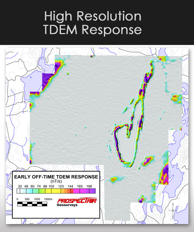
HIGH RESOLUTION TDEM RESPONSE
|
SYSTEM SPECIFICATIONS
Electromagnetic System
| Model | ProspecTEM |
| Operating principle | --- |
| Sensor terrain clearances | 100 – 150 feet (30.5 – 45.7 m) |
| Transmitter: | |
| - Loop Diameter | 5.6 meters |
| - Current Waveform | Half-Sine |
| - Turns | 2 |
| - Pulse Length | 2.75 ms |
| - Frequency | 30 Hz |
| - Loop Area | 25 m² |
| - Peak Current | 2600A |
| - Tow Cable Length | 65 meters |
| - Self-Powered | 13HP Honda coupled with 28 Volts Alternator |
| Receiver: | |
| - Coil Axis | Z |
| - Configuration | Coaxial (Z) |
| - Two Channels | Current and Z |
| - Max Sampling Rate | 1000 points per half cycle at 90 Hz |
| - Survey sampling rate | 1000 points per half cycle at 30 Hz |
| - Sampling | Full waveform recorded |
| - Gates | Programable |
| - On-Time Signal | Recorded |
| Mechanical: | |
| - Survey Speed | 110 km per hour |
| - Transmitter height | 30 meters AGL |
| - Receiver height | 60 meters |
| - Weight (Total) | 200 kg |
Radar Altimeter
| Model | Terra TRA3000/TRI-40 radar altimeter |
| Operating range | 40 – 2 500 feet (12.2 – 762 m) |
| Accuracy | 1 ft (0.3 m) |
| Sampling rate | digital record of 1 Hz |
Navigation System
| Model | T.H.E.M. Geophysics Navigation System |
| GPS: | OmniSTAR Differential Global Positioning System (DGPS) 12-channels |
| Real-time position accuracy: | ± 2 m |
| Sampling rate: | 30 Hz |
Data Acquisition
|
Navigation
|