Radiometrics
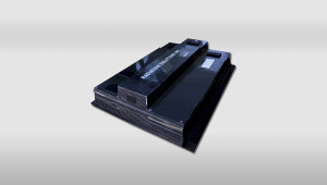
For gamma-ray spectrometry, Prospectair is using the industry leading technology Radiation Solution RS 500, coupled with IRIS, a real time data acquisition and navigation system specifically designed for airborne geophysics applications. It is equipped with precise Satellite navigation, includes real-time display of helicopter path over a geographical image for ease of navigation, and provides reliable data graphics for real time QA/QC purposes.
SYSTEM SPECIFICATIONS
Airborne Spectrometer
| Model | Radiation solution RS-500 Airborne Gamma Ray Spectrometer |
| Channels: | 1024 |
| Differential nonlinearity: | <0.2% over top 99.5% |
| Integral nonlinearity: | <0.01% over top 99.5% |
| Zero dead time: | 0 |
| Baseline restoration: | Digital (IPBR) |
| Pulse shaping: | Digital (AOPS) |
| Pile-up rejection: | Digital (<40nS) |
| Pile-up contamination: | <1% @ 250kcps |
| Sample rate: | .01-10 sec-1 |
| Timing: | Internal/External |
| Gain stabilization: | Automatic multi-peak |
| I/O: | Ethernet, RS-232 19200-115200 bit/s, USB memory stick |
| Operating Temp.: | -30ºC to +45ºC |
Radar Altimeter
| Model | Terra TRA3000/TRI-40 radar altimeter |
| Operating range | 40 – 2 500 feet (12.2 – 762 m) |
| Accuracy | 1 ft (0.3 m) |
| Sampling rate | digital record of 1 Hz |
Navigation system
| Model | T.H.E.M. Geophysics Navigation System |
| GPS: | OmniSTAR Differential Global Positioning System (DGPS) 12-channels |
| Real-time position accuracy: | ± 2 m |
| Sampling rate: | 30 Hz |
Barometric pressure sensor
| Model | Sensotec Model Z |
| Operating range: | 10.5 – 15.5 psia (0 – 1070 mbar) |
| Accuracy: | ± 0.25 % |
| Sampling rate: | 30 Hz |
Temperature and Humidity sensor
| Model | Vaisala HUMICAP HMT100 |
| Operating range: | -40 to +80°C |
| Accuracy: | ± 0.2°C ± 1.7% relative humidity |
| Sampling rate: | 30 Hz |
Data Acquisition
|
Navigation
|


